The Climate Mapping for Resilience and Adaptation (CMRA)
The Climate Mapping for Resilience and Adaptation (CMRA) portal, an easily accessible and interactive geospatial website.


The Climate Mapping for Resilience and Adaptation (CMRA) portal, an easily accessible and interactive geospatial website.
The American Society for Testing and Materials standards and publications.

A website that provides resources and research on building resilience to climate change.
GAR2022 explores how, around the world, structures are evolving to better address systemic risk.

Reference for the 2021 International Residential Code’s seismic provisions, with FEMA guidance for designing earthquake-resilient homes.

World class center for multi-disciplinary disaster prevention research & communication.

FEMA’s guidance on seismic building codes, including resources for adopting and implementing earthquake-resistant design standards in construction.
Research & educational resources on everything earthquakes.
UC Berkeley center publishing earthquake engineering research and ground motion databases.

Interactive USGS maps showing landslide-prone areas, recent landslide events, and susceptibility data for the United States.
Authoritative historical record of every Atlantic hurricane with tracks and intensities.

Real-time phone app radar that also shows nearby earthquakes and the local air quality index.
Guidelines and standards for constructing safe rooms for high-wind events like hurricanes and tornadoes.
Federal guidance on wind retrofits, building codes, and post-storm recovery resources.
Official site of the National Flood Insurance Program with coverage info and flood risk lookup.
Property-level flood risk data and forecasts incorporating climate change projections.
Real-time river forecasts, flood outlooks, and inundation maps across U.S. watersheds.
World class center for multi-disciplinary disaster prevention research & communication.
Interactive sea level rise and coastal flooding maps for any U.S. address.
Real-time tornado watches, warnings, and severe storm forecasts from the National Weather Service.
NOAA research center publishing tornado science, warning improvements, and educational materials.
Federal preparedness guidance covering safe rooms, shelter plans, and household readiness.
FORTIFIED standards for tornado-resistant home construction with research-backed retrofit guidance.
Guidelines and standards for constructing safe rooms for high-wind events like hurricanes and tornadoes.
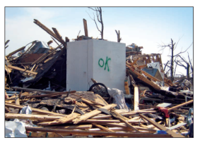
Searchable database of historical tornado events with paths, intensities, and damage records.

US Government air quality index data combined with a map of wildfires.
Real-time phone app radar that also shows nearby earthquakes and the local air quality index.
World class center for multi-disciplinary disaster prevention research & communication.
Research and policy tools for community wildfire adaptation and the wildland-urban interface.
Federal hub for active wildfire incidents, statistics, and interagency coordination resources.